
Waver
Log in

Plan

The motorcycle route planner

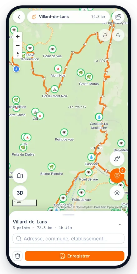
Plot a route on a car sat nav and you get the fastest line: dual carriageways, roundabouts and retail parks. Waver's planner does the opposite. You drop your points on the map, it looks for the road with the corners in it, and you keep control of every segment.

Aerial view of a mountain road drawing a wide hairpin bend across a slope of dry grass.

What the planner does

Routing made for bikes

The routing engine favours twisty roads and skips the stretches that are pointless on a bike. You decide whether to avoid tolls, motorways or tunnels.

Point by point, on a proper screen

Drop a start, a finish and as many stops as you need. Move a point and the line recalculates. Undo, redo, compare two options side by side.

Elevation profile

Cumulative climb tells you far more about a day than distance does. 200 km (125 miles) in the Alps and 200 km across flat farmland are not the same ride.

GPX import and export

Bring in the tracks you already have, rework them on the map, and export them again as GPX for another device.

Folders for touring trips

A five-day tour is five routes that belong together. Folders keep them in one place and turn them into a roadbook you can share.

It carries over to the phone

What you draw here shows up in the mobile app for guided navigation, with spoken instructions under the helmet.

On this page

In progress

Two pieces of work in progress will land directly in the planner: hour-by-hour weather along the route, and an offline mode for riding without a signal. Neither of them is available yet.

Why planning belongs on a big screen

Drawing a route on a phone is possible, but it is not comfortable. The map is small, you never see the whole ride at once, and dragging a waypoint along a 300 km (185 mile) line with your thumb is an exercise in patience. Planning goes much better sitting down, on a screen where you can see the valley you are crossing and the pass that comes after it at the same time.

That split of roles is deliberate: the web to prepare, the phone to ride. Both share the same account and the same routes, so what you put together on a Thursday evening is in your pocket on Sunday morning.

Taking the line back from the algorithm

An automatic calculation, however good, cannot guess that you absolutely want to ride the small road you spotted last year. The planner lets you drop a waypoint anywhere on the map to force the route through it, and rework a single segment without breaking the rest of the ride.

It matters most where the minor road network is dense, the causses of southern France, the Millevaches plateau, the lanes of Normandy, because that is where the gap between the optimal route and the good route is total. Two lines of the same length can produce completely different days out.

Free, and no account needed to try it

The planner opens and works without an account. You can draw, compare, measure the climb and walk away. An account only becomes useful when you want to keep a route, find it again on the phone or share it with someone.

Waver is in open beta and free. A few comfort features, folders among them, are meant to become paid later on. During the beta everybody has access to all of it.

Planning a European tour from abroad

Most people who ride the Alps or the Pyrenees plan them months ahead, from a kitchen table several hundred kilometres away, with a ferry or a Channel Tunnel slot already booked. The planner is built for exactly that: lay out one day at a time, check the climb before you commit to it, and keep the days of the trip together in a folder.

Routing runs on OpenStreetMap data and covers Europe, so a run from Calais or Zeebrugge down to the Col du Galibier is planned the same way as a Sunday loop at home. The site and the mobile app are both available in English.

  • Be honest about daily distance: 250 to 350 km (155 to 220 miles) of mountain road is a full day, not a transit leg.
  • Excluding motorways and tolls is one toggle, which is what you want if you would rather cross France on the D roads than pay for the A6.
  • Rural fuel stations in France often close on Sundays and overnight, so plan the tank, not just the route.
  • Save each day of the trip in its own folder so the whole tour stays in one place instead of six loose files.

Frequently asked questions

Is the Waver motorcycle route planner free?
Yes, and you can use it without creating an account. An account is what lets you save routes, find them again on your phone and share them. Waver is in open beta and free.
Can I create a motorcycle route on a map?
That is the core of the planner: you click on the map to place your start, your finish and your stops, and the route is calculated between each point with a preference for twisty roads.
How do I avoid motorways and tolls on a motorcycle route?
The routing options let you exclude motorways, tolls and tunnels. You can also force the route through a specific road by dropping a waypoint on it, which is the reliable way to keep a pass in the ride.
Can I import a GPX file into the planner?
Yes. The planner imports existing GPX files, so you can take a track you found elsewhere, reshape it on the map, then export it again or carry it to the phone for guided navigation.
Does it work outside France?
Yes. The routing data is OpenStreetMap and covers Europe, so you can plan from a ferry port or an airport all the way to the Alps. France and the Alps are the best-tested ground because the team rides there, and we would rather say that than pretend the coverage is identical everywhere.

Draw your first route now

The planner is open, free, and does not ask for an account. Drop two points and see what it comes back with.

Updated 16 August 2026 · Free, premium included during the beta

Install

How to get the app

Waver is in beta. On Android the Play listing is open to everyone. On iPhone the app goes through TestFlight. A minute either way.

Android

  1. 01

    Download the app

    The Play listing is public: the link opens it in Google Play and the install starts right away.

    Get it onGoogle Play
  2. 02

    If the install is refused

    It happens to a Google account Play does not recognise as a tester. Joining the test programme unlocks the listing, then try again.

    Join the test onGoogle Play

iPhone

  1. 01

    Install TestFlight

    Apple's free app that every test build goes through.

    Download on theApp Store
  2. 02

    Join the Waver beta

    The link opens the invitation in TestFlight: accept it and Waver installs.

    Open inTestFlight

No App Store listing yet: it will land with the public release, once the test programme ends.