
Waver
Log in

The app

The Waver motorcycle app

Waver puts into one app what most riders currently do with three: a planner to prepare, a sat nav to ride, and a chat group to organise the outing. It is built by two riders, from what actually got in their way on the bike rather than from a competitor's feature list.

A helmeted rider checks their phone, standing behind their naked bike, headlight on under a hazy sky.

What Waver does

Plan on a big screen

Draw your routes on the web, with a calculation that favours twisty roads and leaves out the stretches that add nothing on a bike.

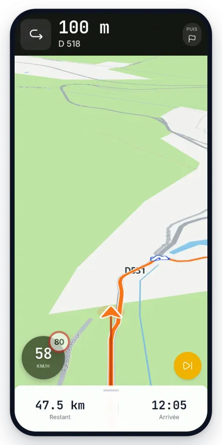
Ride with guidance

Guided GPS navigation on the phone, with spoken instructions meant to be heard under a helmet rather than read off a screen.

Ride with other people

Post a ride, invite your friends or open it to the community, and keep the conversation attached to that ride before and during the day.

Share your position

A live tracking link so the people at home can see where you have got to, without you stopping at a lay-by to send a message.

Keep the track

Every recorded ride becomes a trip with its GPS track, its climb, its speeds and its stops, ready to be looked at again on a big screen.

A garage

Your bikes, their mileage and their servicing, so you know where you stand before the next long trip rather than after it.

On this page

In beta

Waver is in open beta: the app is usable day to day, it moves fast, and there are still rough edges. Feedback goes through the form built into the app or through the Discord.

Built by riders, not aimed at a market

Waver is written by Samuel and Morgan, two motorcyclists. Every feature comes from something that annoyed them on the road, not from a checklist of what the competition ships. That is also why the app does not try to do everything: it does what its authors actually use.

It runs on open data, OpenStreetMap first of all, and on an in-house routing engine. That choice costs more work than plugging into a commercial map API, but it means the project does not depend on somebody else's pricing decisions, and it lets us give something back to the map everyone uses.

Web to plan, phone to ride

The split is deliberate. Preparing a 300 km (185 mile) route with your thumb on a phone screen is miserable, and a planning map is of no use at all at 90 km/h in the rain. The site handles preparation and looking back at what you rode; the mobile app handles navigation and recording.

The account is shared between the two: what you draw on the web is in your pocket when you set off, and what you ride comes back to the web to be looked at properly.

Free, with premium open during the beta

Waver is in open beta. Signing up is free, and every feature, including the ones planned to become paid later, is open to all accounts during this period.

In exchange we expect feedback. Beta users decide, in practice, the order in which the rest gets built, and there is a feedback form inside the app for that.

Where it works, and on what

The mobile app runs on Android and on iPhone, but it is still a test programme: searching for Waver in a store returns nothing for now, and you get in by invitation. The steps for both platforms are at the bottom of this page. We would rather write that here than have you look for us in a store and find nothing.

The maps and routing cover Europe, so the planner works whether you are laying out a Sunday loop in Yorkshire or a two-week tour through the Alps. Both the site and the app are available in English and French. France, and the Alps in particular, are the best-tested ground because that is where the two of us ride.

Frequently asked questions

Is the Waver motorcycle app free?
Yes. Waver is in open beta and free. Some comfort features are meant to become paid once the beta ends, but they are open to every account during this period.
Does Waver work offline?
Not yet. Navigation currently needs a connection. An offline mode, with maps and routes downloaded ahead of time, is being worked on but is not available, so do not plan a remote trip around it.
Which phones is Waver available on?
The mobile app is distributed on the Play Store for Android. The planner and your saved routes work in any browser, on a computer or on a phone, including iPhone.
Does Waver detect crashes?
No, and it is worth saying plainly: Waver has no crash detection and must not be treated as a safety device. It does offer live position sharing, which is useful but different: the people following you see where you are, and nothing is sent automatically if something happens.
Can I use Waver for a motorcycle tour in France or the Alps?
Yes, that is one of the things it is best at. Routing covers Europe, you can plan each day of the tour and keep them together in a folder, and the guided navigation on Android will follow the route you drew. The app is available in English, and distances are shown in metric like the road signs you will be reading.

Start without installing anything

The planner runs in your browser, free and without an account. It is the quickest way to see whether Waver suits the way you ride.

Updated 16 August 2026 · Free, premium included during the beta

Install

How to get the app

Waver is in beta. On Android the Play listing is open to everyone. On iPhone the app goes through TestFlight. A minute either way.

Android

  1. 01

    Download the app

    The Play listing is public: the link opens it in Google Play and the install starts right away.

    Get it onGoogle Play
  2. 02

    If the install is refused

    It happens to a Google account Play does not recognise as a tester. Joining the test programme unlocks the listing, then try again.

    Join the test onGoogle Play

iPhone

  1. 01

    Install TestFlight

    Apple's free app that every test build goes through.

    Download on theApp Store
  2. 02

    Join the Waver beta

    The link opens the invitation in TestFlight: accept it and Waver installs.

    Open inTestFlight

No App Store listing yet: it will land with the public release, once the test programme ends.